Thursday, October 13, 2005

Leek, Denford, Cheddleton and I Told Me So

I decided to fill in a gap in my knowledge with another trip to Leek. I went by bus, which took ages, so that I didn't get there until 10:50. The stroll down the Leek Arm was pleasant, with a good view over the Churnet Valley and surroundings. I reached Hazlehurst, where the Leek Arm joins the main line of the Caldon Canal, at around 12:30 and so decided to stop at the Holly Bush, in Denford, for lunch. This was a good idea, as both food and beer were excellent.


Strolling on, the weather turned a little damp, so I made for the Boat, in Cheddleton. This was also a good idea, as I was able to sit outside, under cover, with another good pint of beer.

Sadly, the weather did not improve and I was now a bit behind time. The Black Lion, at Consallforge, was closed, with a notice outside announcing that it would now be closed on Thursdays. Possibly a blessing, given how late it was getting, but a bit of a disappointment, at the time. The rest of the walk became a bit of a plod, ending at the bus stop in Oakamoor.

One thing stands out from the latter part of the walk. In a previous post, I said that it would take only one bridge on the Caldon Canal, in an obvious place, with planks bolted to it, to make me look stupid. Sure enough, Cherry Eye Bridge, near Froghall, has planks bolted to both sides of the arch on the towing path side of the canal, each with grooves worn into it by towing ropes.

Friday, September 23, 2005

Finding The Source

Last weekend, I took a trip up to the north of Leek, high into the Stafforshire Moorlands to try to find the source of the Churnet. I had located a couple of candidates on the Ordinance Survey map and was aiming for a side-road, off the A53, that passed near. Unfortunately, I missed the turning and ended up in Buxton. It was a nice sunny day, though, so I had a pleasant walk around the town.

Heading back down the A53, I found my target, near to The Winking Man pub. I found both of my map targets were gullies, with water running off the moors down towards the infant Churnet. Unfortunately, it had clouded over, giving that bright overcast that makes photography difficult, so my efforts were not brilliant.

I got better results from the top of Ramshaw Rocks, on the other side of the A53, which offer an excellent view over the surrounding area. The climb was not difficult, although some bits were a bit vertigo-inducing. Carrying my lunch up with me probably wasn't a great idea.


Finally, I took a trip down to Froghall Wharf to look for a bridge, next to bridge 55 on the Caldon Canal, that carried the Foxt road over one or more of the Caldon Low railways. It is visible in photos from the early 20th century and I wondered if anything was still there. Sure enough, though most of it is now buried, the top foot-or-so of the arch is still visible and you can see daylight from the other side.

Tuesday, August 30, 2005

A Salt Road and Spotting the Blindingly Obvious

Took a couple of trips up to "the valley" in mid-August, both using Alton as a starting point. On the first trip, I headed off down Saltersford Lane; an old pack-horse road with an obvious purpose. This was excellent walking; a clear path between stone walls with no stroppy livestock. Unfortunately, it peters out a bit as it reaches a field, overlooking the river where a Salters Bridge apparently once stood. When the Uttoxeter Canal was dug, a Saltersford or Saltersfield Lane Bridge was provided, but the railway company seems not to have bothered. Thus, the modern path veers south towards Denstone. The original line appears to have been a farm crossing on the railway and a remnant of a hedge suggests a line to the river, but nothing much else is visible.

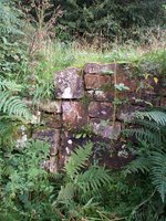
Just because I haven't spotted it doesn't mean there isn't something there, though. At Crumpwood Weir, a little further back up the valley, is a loop of the Uttoxeter Canal that 
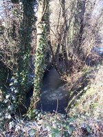
originally took boats through the river. This wasn't much use to the railway, which is why it's still there. On two previous visits, I had noticed a line of stones in the undergrowth, next a modern road, that runs across the line of the canal. I had wondered, initially, whether this might be the remains of a lock, but had concluded that it was, probably, just a wall. On this, my third visit, it suddenly became blindingly obvious to me that there was a great big water-filled stretch of canal leading up to this location and that there were really two lines of stones. Clearly, a lock, and, probably, Carringtons or Weir Lock, that lowered the canal to river level for the crossing. Pushing through the undergrowth for a better look just rammed it home; I'd missed something quite obvious that had stared me in the face. This was only the start.

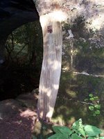
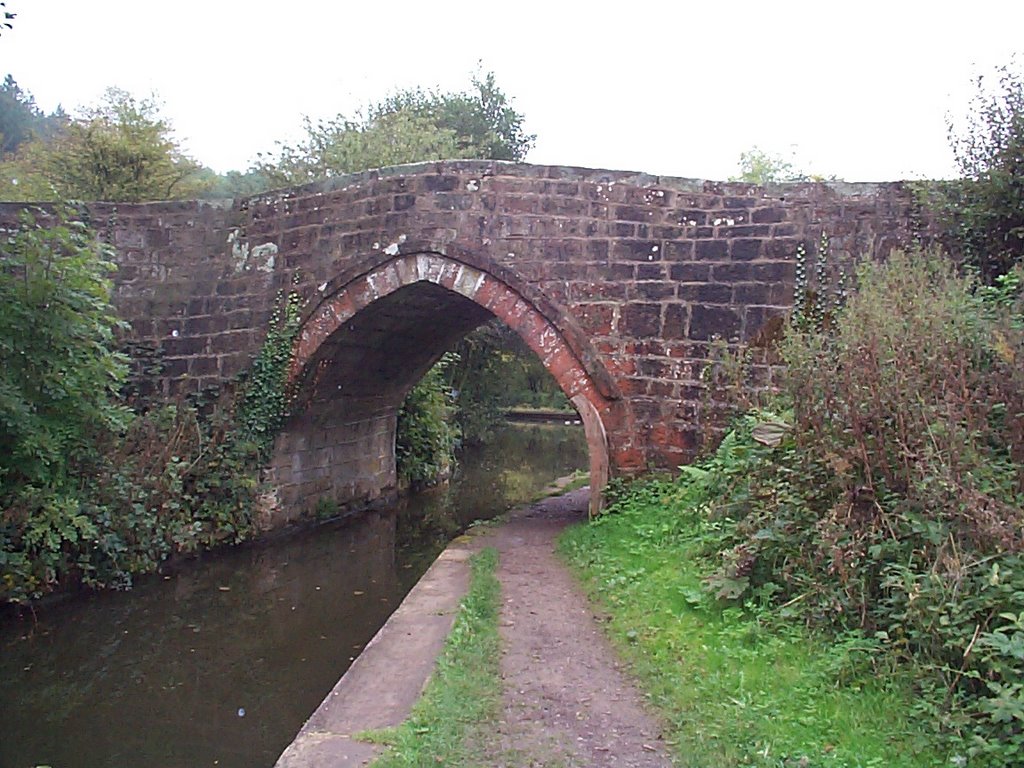
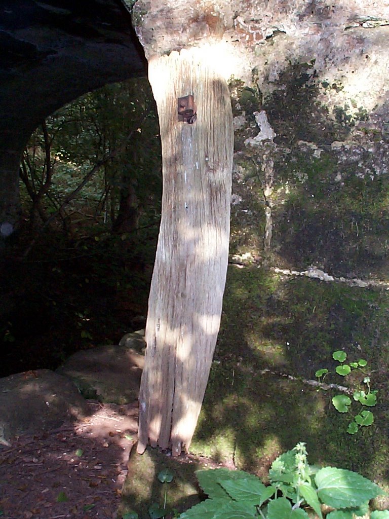
A short distance up the valley from the old lock, is an old bridge, called Seventy Bridge, which is so obvious that even I found it at the first attempt; its on the Ordinance Survey map, for a start. On my recent visit, there, I noticed that there is a plank of wood attached to it, where the towing path passes under. There is rope damage to the stonework behind it. The penny finally dropped. The plank is held in place by a bolt, exactly the same as a bolt sticking out of the remains of Morris's Bridge, further up the valley. I had wondered what the bolt on Morris's Bridge was for but had completely failed to take any interest in this much-more-obvious feature on Seventy Bridge. Mystery solved; some kind of rope damage protection. All I need, now, is to find a bridge on the Caldon Canal or the main line of the Trent and Mersey, with a similar device in place, at a location I've known for years, to feel totally stupid.


Absence of evidence is not evidence of absence.

Friday, July 29, 2005

Churnet Valley

Let's begin by referring to the website at www.churnet.co.uk. I'm trying to become a competent web developer and this is where I'm starting. I'm also a keen walker and I think the Churnet Valley is a gem.